Illustration 4: Intermediate geospatial technologies
Introduction
Spatial technologies are used to gather information about the world around us. Intermediate geospatial technologies allow students to do more with data. Compared to simple geospatial tools, intermediate geospatial technologies and tools allow increased opportunities to engage students in higher-order thinking. They visualise, measure, manage, analyse and present information about the natural and built world. They are more easily customised, and consequently students can enter their own data for analysis.
See the Introduction to intermediate geospatial technologies video for more information on spatial technologies. Also, for a great introduction to the value of geospatial technologies in our society, view Geospatial revolution.
Classroom application
The basis of a Geographic Information System (GIS) is the connection between a database (or table of information) and locations on a map. In the image below, the map contains four layers:
- a satellite image as a base
- plate boundaries
- earthquakes
- volcanoes.
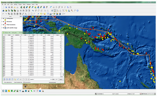
An example of the use of layers in GIS application
Each layer has its own table (known as an attribute table) and that table contains data about that layer. For instance, for the layer displaying earthquakes, the attribute table attached to that layer, open in the image, contains information such as the magnitude, depth and date of the tremor.
Each row in the table is linked to a feature (eg, earthquake) on the map.
The way the layer is displayed can be changed according to the data in the table, so the symbols representing earthquakes, for example, could be changed such that earthquakes with a larger magnitude are displayed using a larger point.
It is this connection between the underlying data and the information on the map that makes these tools appealing for classroom use.
Intermediate geospatial technologies allow greater depth of analysis of data than simpler geospatial technologies as they allow the user to import their own data, manage data and manipulate the data. Students can begin to ask powerful questions and examine complex relationships between different types of data across a range of scales. Intermediate geospatial technologies, therefore, lend themselves to use in geographical inquiry. They can be used to deeply investigate issues and provide students with opportunities to:
- view information
- collect and manipulate data
- visualise spatial patterns in data
- examine cause and effect
- compare data in different areas
- create and share useful maps that adhere to common map conventions.
Professional learning about geospatial technologies
It is strongly recommended that you become familiar with the general concepts associated with geospatial technologies. These concepts include:
- spatial data formats including vector, raster and attribute
- concept of layering data
- spread sheet principles
- map projections
- cartographic principles.
GPS and other mobile technologies
Global Positioning System (GPS) refers to a network of satellites around the earth that provide location information to receivers on the ground. A GPS receiver can be found in GPS units, most mobile phones, in-car GPSs and in some cameras. This ever-present network allows teachers to use a range of ICTs to extend students' geographical experiences using the world immediately around them.
Geocaching could be described as a global GPS 'treasure hunt'. Geocaching can be done with a GPS (free) or a mobile application (which may require payment). The idea of a location-based treasure hunt could be extended for use within your own school grounds or as a means of moving students around while in the field.
In a similar vein, Quick Response (QR) codes can be used as a way of informing students while in the field or while mobile. QR codes are digital barcodes that can point to any range of things – a website, document, audio file, video file or even a location. QR codes can be created online and read by many free mobile applications.
Apart from those mentioned, there are many mobile applications for smartphones and tablet computers that are relevant and useful for geography teachers. Applications that might be useful include apps that replicate a GPS interface on a mobile device, QR readers, and some more specific applications that use a mapping interface with some analysis tools.
The online resource Intermediate geospatial technologies: GPS and other mobile technologies provides information and classroom resources applicable to these technologies.
Data
It is important to fully plan and consider the required outcomes when undertaking any inquiry using geospatial technologies. This can identify the needs of the user and can help to ensure that useful and reliable data is collected. Some data, such as local aerial images, road or cadastral data, demographic data or data about the natural world, may be needed to begin an investigation.
Getting useful local base data such as roads, property boundaries, demographic data, land-use data or data on natural resources can be difficult due to the fragmented nature of spatial data provision. Your local council may be able to assist in accessing useful local data. State governments offer data and online mapping tools across a range of departments for a wide range of different users.
Alternatively, industry-standard GIS (such as Quantum GIS) allows users to join data from tables or spread sheets to spatial data for display on a map. Students could create their own tables and manually input their data before displaying this data in Quantum GIS (QGIS) using the 'join' function.
The important point to remember if undertaking this process is to find a common field for the table to join to the spatial data. For example, if you wish to map global infant mortality rates, create a table with the same country names as your spatial data's table and enter your data. Use those country names to join your two tables later so your infant mortality data is displayed with your spatial data.
Intermediate geospatial technologies: data provides a summary of useful sources for local, state, national and international data.
Questions for reflection
- Do you really need to use intermediate geospatial technologies for your task or could it be done using the simpler geospatial technologies covered in previous illustrations? There is no point grappling with what is admittedly challenging software and data if there are other tools that can be used to achieve the same learning outcomes.
- Are there any immediate opportunities to incorporate QGIS (or a similar geospatial technology package) immediately into your work program? Any opportunity to familiarise your students with the software should be taken so don't rule out using lower-order thinking tasks (eg, measuring distances on an aerial image, navigating to locations) while you are familiarising yourself with the more advanced aspects of the software (eg, creating layers, manipulating and managing attribute data, querying information).
- Are there any opportunities to collaborate with others? You could partner with an outside agency such as a local catchment association, geospatial professional or government agency to identify and address meaningful issues while also benefitting from the expertise of these professionals. The geospatial industry is very willing to assist.
Resources
Penn State Public Broadcasting. Geospatial revolution. Retrieved June 2019, from: http://geospatialrevolution.psu.edu/.
YouTube. Introduction to intermediate geospatial technologies (duration, 00:54). Retrieved June 2019, from: https://www.youtube.com/watch?v=Odrx0sp1GBk.
Contour Education. Intermediate Geospatial Technologies. This site provides a blog, and a wealth of information to support classroom applications, professional learning, GPS and other mobile technologies and data resources. Retrieved June 2019, from: https://geogspaceintermediategeospatial.blogspot.com/p/classroom-application.html